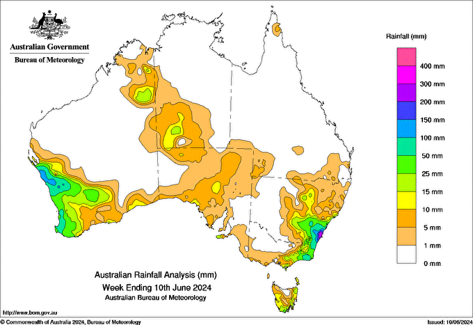
IN THE 24 hours to 9 am 4 June, a trough and cold front brought a band of rain and showers from the Kimberley in Western Australia, through the Northern Territory and across much of South Australia, with totals of 1 to 10 mm generally, and some areas recording over 15 mm.
Between 6 and 8 June, a trough developed off the New South Wales south coast, deepened into a coastal low and interacted with humid south-easterly flow, generating widespread rainfall and localised heavy falls across coastal and adjacent inland areas. Across the Illawarra district, weekly rainfall totals exceeded 100 mm, with isolated totals over 200 mm. Some stations had June daily rainfall total records. Culburra Treatment Works (NSW) recorded the highest weekly total of 269.6 mm, and the highest daily total of 187 mm in the 24 hours to 9 am on the 6th.
In Western Australia, a cold front brought heavy rain from 7 to 10 June across large areas of the south-west that have had severe rainfall deficiencies in recent months. Weekly totals were above 100 mm in parts of Central West and Gascoyne districts, and above 50 mm along the coast in Lower West and South West districts. Many stations had June record daily or multi-day rainfall totals, including Kalbarri with 69.2 mm in the 24 hours to 9 am on the 9th, and Mullewa with 130.6 mm over the 3 days to 9 am on the 9th.
Weekly totals of 1 to 25 mm were recorded along the south coast of Australia, across most of Tasmania, and in parts of far north and southern Queensland and parts of northern and inland New South Wales.
HAVE YOUR SAY